
Following the Kobe earthquake on January 17, 1995, National Research Institute for Earth Science and Disaster Resilience (NIED) established four nationwide land observation networks, Hi-net, K-NET, KiK-net, and F-net, to improve understanding and assessments of earthquakes and their impacts. NIED also established V-net at 44 volcanoes to monitor volcanic activity.
After the Tohoku earthquake on March 11, 2011, a seafloor observation network, S-net, was installed from off Hokkaido to off Chiba Prefecture for rapid detection of offshore earthquakes and tsunamis. In April 2016, NIED took over the operation of DONET, another seafloor network in Kumano-nada and off Kii Channel, from Japan Agency for Marine-Earth Science and Technology (JAMSTEC).
Furthermore, the construction of the Nankai Trough Seafloor Observation Network for Earthquakes and Tsunamis (N-net), extending from offshore Kochi Prefecture to Hyuga-nada region, began in 2019 and was completed in June 2025.
![]()
Hi-net is a high-sensitivity seismograph network consisting of nearly 800 stations with an average spacing of 20 km. The seismometers are installed at the bottom of boreholes at a depth of 100-3500 m to reduce noise caused by winds, ocean waves, and human activity. The observed data is continuously transmitted to NIED to be used for researching microearthquakes and other seismological phenomena.

3D distribution of earthquakes from 2012 to 2016 captured by Hi-net

Sensor unit of Hi-net/KiK-net
K-NET is a strong motion seismograph network consisting of more than 1,000 stations with an average spacing of 20 km. The seismometers are installed on the ground surface and stay on scale even during strong shaking. Most of the K-NET seismometers are officially approved as seismic intensity meters. Seismic intensity from K-NET supports government decision-making.

Seismometer of K-NET

Station of K-NET
KiK-net is a strong motion seismograph network consisting of pairs of seismometers installed on the ground surface and in the borehole together with the Hi-net high-sensitivity sensors. Surface and downhole observations provide important data to understand amplification of strong shaking near the surface.

Strong motion monitor

Station of Hi-net/KiK-net
F-net is a broadband seismograph network consisting of about 70 stations nationwide. The seismometers are installed at the end of tunnels, several dozen meters from the entrance, where temperature and pressure are stable, and accurately measure ground motion over a wide frequency range. These broadband measurements provide useful implications for earthquake source mechanisms and the structure of the Earth.

F-net station

Entrance of an F-net station

Three-component broadband seismometers with a strong motion velocity seismometer
V-net is an observation network operated at 44 volcanoes in an effort to develop eruption forecast and volcano hazard mitigation. Several types of instruments are installed, including borehole seismometers, borehole tiltmeters, GNSS receivers, and broadband seismometers. The borehole measurements at Mt. Miyake observed precursors to the eruption in 2000. At Mt. Asama, a radar interferometer is also installed, to monitor surface deformation from magma movement before and during eruptions.

V-net station at Mt. Iwate

V-net station at Komagatake, Hokkaido
S-net is an ocean bottom observation network consisting of 150 observation units from off Hokkaido to off Chiba Prefecture. Each unit contains seismometers and water pressure gauges to observe offshore earthquakes and tsunamis. All the data is transmitted to the land stations by fiber-optic cable and arrives at NIED in real time.

Observation units of S-net

Water pressure gauges in the S-net observation units

Laying operation of S-net
DONET is an ocean bottom observation network consisting of 51 stations in Kumano-nada and off Kii Channel, focused on monitoring of earthquakes and tsunamis in the region. A wide variety of instruments are installed, including strong motion seismometers, broadband seismometers, water pressure gauges, hydrophones, differential pressure gauges, and thermometers. The network is designed to be expandable and replaceable, allowing for adding stations and replacing instruments. The data is transmitted to research institutes and universities in real time, and improves precision and warning times of earthquake early warning and tsunami warnings/advisories by JMA.

Science node

Pressure sensing system

Ground-motion sensing system

Land station of DONET
NIED has established a new observation system, N-net, consisting of 36 stations equipped with seismometers and pressure gauges, to continuously monitor earthquakes and tsunamis in the anticipated source region of the Nankai Trough earthquake, where no observation networks had previously been deployed (off the coast of Kochi Prefecture to the Hyuga-nada).
N-net is a hybrid system that, like S-net, connects observation instruments using submarine fiber-optic cables to cover a wide offshore area, while also offering expandability similar to DONET. With N-net, earthquakes occurring in this ocean area can be directly detected up to approximately 20 seconds earlier, and tsunamis up to about 20 minutes earlier.

N-net observation equipment on the cable ship

Inline observatory being laid from cable ship

Land station of N-net
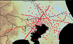
Earthquake Research Institute (ERI) at the University of Tokyo established MeSO-net consisting of about 300 stations with a spacing of 2-5 km, to measure ground shaking and monitor seismic activity in the Tokyo metropolitan area. NIED took over the operation of MeSO-net from ERI in April 2017.
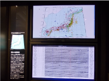
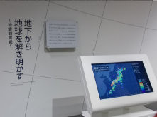
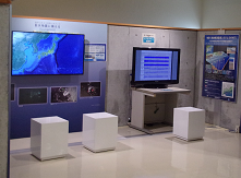
Real-time seismic data from MOWLAS is displayed at several museums, which includes maps showing seismic activity and earthquake seismograms.
National Museum of
Nature and Science
National Museum of Emerging
Science and Innovation
Nagoya City Science Museum
Muroto Global Geopark Center
